CONSTRUCTION
Cut Time, Costs and Safety Risks
E Construction estimates that using drones saves the company $50,000 to $60,000 a year because the surveying process has been reduced from nearly two weeks to 30 minutes, according to Chad Harrison, aggregates and environment manager. He works with drones for E Construction, which has more than 650 employees providing products and services throughout Saskatchewan, Alberta and the Northwest Territories.
We are the best
With same day consultation, next day flight and next day delivery, it is easy to see that we value the time of our clients and want to provide vital information as fast as possible. Speed is crucial as if there is a problem it can be fixed in the shortest amount of time keeping the project on schedule and investors happy.
Construction Statistics
239%
Year over Year Growth in the Construction Industry
$177 Billion
Labor Costs wasted per year fixing mistakes, reworks and other related activities
20%
Reduction in Costly Time Delays
The Drone Advantages
Quick and Precise
You are kept busy enough managing the contractors, engineers, excavators, subcontractors, and other moving pieces of your project. A complete view of your entire site or project may be captured using drones on-demand, and the data is immediately accessible. Due to the low altitudes at which they fly and the high-resolution camera technology available on drones, data collected by drones is oftentimes faster, more precise, and gives a closer picture of your project.
Time and Cost Savings
The correct tool, when used properly, can help you save both time and money. Drones are effective tools that can be deployed in a matter of minutes and collect remarkably accurate data in a fraction of the time required by conventional techniques. In a few of hours, one drone equipped with a high-resolution camera can cover huge stretches of roads, highways, runways, and lots more.
Transparency and Accuracy
Hardware is only the beginning of drone technology’s developments. Drones record more data than just pictures. A digital map of your location is created using the drone’s photographs that have important metadata, such GPS coordinates, embedded in them. Then, photogrammetry software utilizes that metadata to produce extremely precise models and maps.
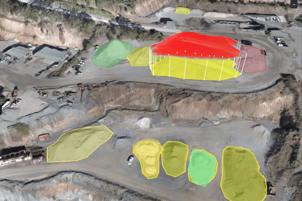
3D Orthographic Maps
why orthographic maps are so useful
It’s Easy
The Simple 3 Step Process
Day 1
Schedule a Day
We fly 7 days a week for the quickest turnarounds
Day 2
We Fly
2D & 3D Maps, Stockpile Measurements and Progress Pictures can all be captured the SAME DAY
Day 3
Next Day Delivery
The rendering of the maps can take overnight to process. Once complete everything is sent to you!